Iowa State Facts
Iowa State Statistics
About: Find out about your mental health and make a difference to everyday in your life.
 Des Moines, IA
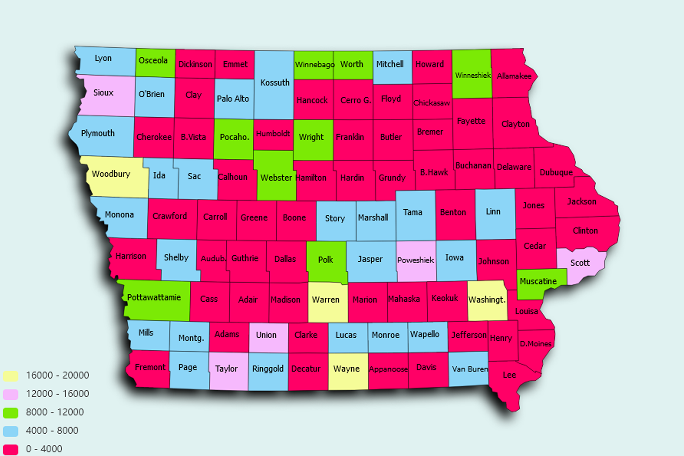
  Population: 209220
Cedar Rapids, IA Population: 129195
Davenport, IA Population: 102448
Sioux City, IA Population: 82517
Iowa City, IA Population: 73415
Waterloo, IA Population: 68364
West Des Moines, IA Population: 63325
Ames, IA Population: 63266
Council Bluffs, IA Population: 62245
Dubuque, IA Population: 58436
Ankeny, IA Population: 53801
Urbandale, IA Population: 43150
Cedar Falls, IA Population: 40859
Marion, IA Population: 36774
Bettendorf, IA Population: 35122
Marshalltown, IA Population: 27727
Mason City, IA Population: 27458
Clinton, IA Population: 26246
Burlington, IA Population: 25539
Ottumwa, IA Population: 24682
Fort Dodge, IA Population: 24594
Muscatine, IA Population: 23888
Johnston, IA Population: 20359
Coralville, IA Population: 20349
Waukee, IA Population: 17705
Clive, IA Population: 17052
Altoona, IA Population: 16105
North Liberty, IA Population: 15386
Indianola, IA Population: 15305
Newton, IA Population: 15150
Boone, IA Population: 12633
Oskaloosa, IA Population: 11541
Spencer, IA Population: 11206
Storm Lake, IA Population: 10895
Fort Madison, IA Population: 10764
Keokuk, IA Population: 10692
Pella, IA Population: 10337
Waverly, IA Population: 10106
Carroll, IA Population: 10007
Norwalk, IA Population: 9859
Grimes, IA Population: 9786
Le Mars, IA Population: 9764
Fairfield, IA Population: 9750
Pleasant Hill, IA Population: 9159
Grinnell, IA Population: 9069
Mount Pleasant, IA Population: 8647
Denison, IA Population: 8390
Perry, IA Population: 8151
Decorah, IA Population: 7957
Creston, IA Population: 7839
Webster City, IA Population: 7788
Clear Lake, IA Population: 7682
Charles City, IA Population: 7513
Sioux Center, IA Population: 7389
Washington, IA Population: 7349
Knoxville, IA Population: 7244
Hiawatha, IA Population: 7157
Atlantic, IA Population: 6842
Nevada, IA Population: 6779
Oelwein, IA Population: 6181
Eldridge, IA Population: 6162
Orange City, IA Population: 6151
Estherville, IA Population: 6121
Maquoketa, IA Population: 6012
Independence, IA Population: 5986
Red Oak, IA Population: 5573
Algona, IA Population: 5479
Centerville, IA Population: 5433
Anamosa, IA Population: 5425
Clarinda, IA Population: 5362
De Witt, IA Population: 5253
Glenwood, IA Population: 5242
Iowa Falls, IA Population: 5173
Asbury, IA Population: 5171
Vinton, IA Population: 5159
Winterset, IA Population: 5141
Cherokee, IA Population: 5139
Sheldon, IA Population: 5106
Manchester, IA Population: 5087
Shenandoah, IA Population: 5032
Harlan, IA Population: 5013
Iowa State, constituent state of the United States of America. It was admitted to the union as the 29th state on December 28, 1846. As a Midwestern state, Iowa forms a bridge between the forests of the east and the grasslands of the high prairie plains to the west. Its gently rolling landscape rises slowly as it extends westward from the Mississippi River, which forms its entire eastern border. The Missouri River and its tributary, the Big Sioux, form the western border, making Iowa the only U.S. state that has two parallel rivers defining its borders.
About: Find out about your mental health and make a difference to everyday in your life.