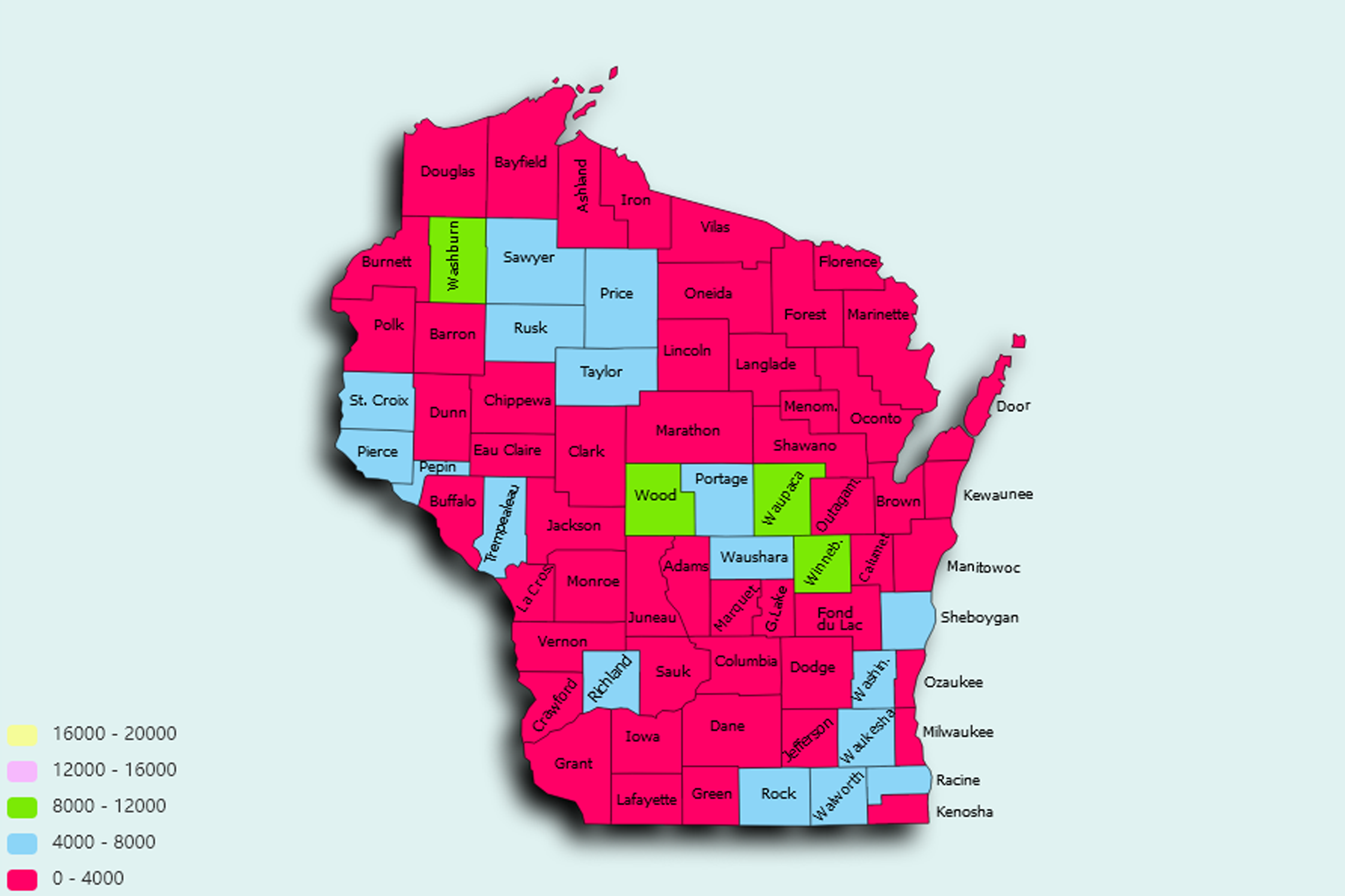
Wisconsin State Statistics
About: The typewriter, invented in Milwaukee in 1867
![]() Population: 599642
Population: 599642
![]() Population: 245691
Population: 245691
![]() Population: 104891
Population: 104891
![]() Population: 99894
Population: 99894
![]() Population: 78065
Population: 78065
![]() Population: 73971
Population: 73971
![]() Population: 71489
Population: 71489
![]() Population: 67684
Population: 67684
![]() Population: 66621
Population: 66621
![]() Population: 64009
Population: 64009
![]() Population: 60624
Population: 60624
![]() Population: 52440
Population: 52440
![]() Population: 48775
Population: 48775
![]() Population: 47102
Population: 47102
![]() Population: 42917
Population: 42917
![]() Population: 39842
Population: 39842
![]() Population: 39302
Population: 39302
![]() Population: 37982
Population: 37982
![]() Population: 37157
Population: 37157
![]() Population: 36881
Population: 36881
![]() Population: 36278
Population: 36278
![]() Population: 35974
Population: 35974
![]() Population: 35053
Population: 35053
![]() Population: 33102
Population: 33102
![]() Population: 31752
Population: 31752
![]() Population: 31692
Population: 31692
![]() Population: 27154
Population: 27154
![]() Population: 26705
Population: 26705
![]() Population: 26658
Population: 26658
![]() Population: 26293
Population: 26293
![]() Population: 25855
Population: 25855
![]() Population: 24708
Population: 24708
![]() Population: 24621
Population: 24621
![]() Population: 24555
Population: 24555
![]() Population: 23891
Population: 23891
![]() Population: 23509
Population: 23509
![]() Population: 21236
Population: 21236
![]() Population: 20919
Population: 20919
![]() Population: 20400
Population: 20400
![]() Population: 19901
Population: 19901
![]() Population: 18987
Population: 18987
![]() Population: 18691
Population: 18691
![]() Population: 18671
Population: 18671
![]() Population: 18385
Population: 18385
![]() Population: 18341
Population: 18341
![]() Population: 17966
Population: 17966
![]() Population: 17604
Population: 17604
![]() Population: 17111
Population: 17111
![]() Population: 16536
Population: 16536
![]() Population: 16319
Population: 16319
![]() Population: 16237
Population: 16237
![]() Population: 15799
Population: 15799
![]() Population: 15215
Population: 15215
![]() Population: 15175
Population: 15175
![]() Population: 15040
Population: 15040
![]() Population: 14988
Population: 14988
![]() Population: 14332
Population: 14332
![]() Population: 14280
Population: 14280
![]() Population: 14122
Population: 14122
![]() Population: 13965
Population: 13965
![]() Population: 13943
Population: 13943
![]() Population: 13942
Population: 13942
![]() Population: 13415
Population: 13415
![]() Population: 13331
Population: 13331
![]() Population: 13067
Population: 13067
![]() Population: 13039
Population: 13039
![]() Population: 12887
Population: 12887
![]() Population: 12651
Population: 12651
![]() Population: 12430
Population: 12430
![]() Population: 12326
Population: 12326
![]() Population: 12281
Population: 12281
![]() Population: 12102
Population: 12102
![]() Population: 12085
Population: 12085
![]() Population: 12067
Population: 12067
![]() Population: 12003
Population: 12003
![]() Population: 11878
Population: 11878
![]() Population: 11586
Population: 11586
![]() Population: 11531
Population: 11531
![]() Population: 11506
Population: 11506
![]() Population: 11460
Population: 11460
![]() Population: 11437
Population: 11437
![]() Population: 11377
Population: 11377
![]() Population: 10897
Population: 10897
![]() Population: 10839
Population: 10839
![]() Population: 10813
Population: 10813
![]() Population: 10781
Population: 10781
![]() Population: 10740
Population: 10740
![]() Population: 10541
Population: 10541
![]() Population: 10309
Population: 10309
![]() Population: 10178
Population: 10178
![]() Population: 10157
Population: 10157
![]() Population: 9975
Population: 9975
![]() Population: 9871
Population: 9871
![]() Population: 9667
Population: 9667
![]() Population: 9597
Population: 9597
![]() Population: 9564
Population: 9564
![]() Population: 9547
Population: 9547
![]() Population: 9533
Population: 9533
![]() Population: 9466
Population: 9466
![]() Population: 9364
Population: 9364
![]() Population: 9328
Population: 9328
![]() Population: 9205
Population: 9205
![]() Population: 9169
Population: 9169
![]() Population: 9044
Population: 9044
![]() Population: 8679
Population: 8679
![]() Population: 8443
Population: 8443
![]() Population: 8433
Population: 8433
![]() Population: 8286
Population: 8286
![]() Population: 8182
Population: 8182
![]() Population: 8179
Population: 8179
![]() Population: 7955
Population: 7955
![]() Population: 7948
Population: 7948
![]() Population: 7921
Population: 7921
![]() Population: 7861
Population: 7861
![]() Population: 7859
Population: 7859
![]() Population: 7816
Population: 7816
![]() Population: 7778
Population: 7778
![]() Population: 7757
Population: 7757
![]() Population: 7746
Population: 7746
![]() Population: 7646
Population: 7646
![]() Population: 7601
Population: 7601
![]() Population: 7595
Population: 7595
![]() Population: 7497
Population: 7497
![]() Population: 7427
Population: 7427
![]() Population: 7388
Population: 7388
![]() Population: 7340
Population: 7340
![]() Population: 7216
Population: 7216
![]() Population: 7182
Population: 7182
![]() Population: 7166
Population: 7166
![]() Population: 7155
Population: 7155
![]() Population: 6981
Population: 6981
![]() Population: 6802
Population: 6802
![]() Population: 6755
Population: 6755
![]() Population: 6740
Population: 6740
![]() Population: 6691
Population: 6691
![]() Population: 6664
Population: 6664
![]() Population: 6565
Population: 6565
![]() Population: 6555
Population: 6555
![]() Population: 6278
Population: 6278
![]() Population: 6176
Population: 6176
![]() Population: 6102
Population: 6102
![]() Population: 6018
Population: 6018
![]() Population: 5842
Population: 5842
![]() Population: 5785
Population: 5785
![]() Population: 5765
Population: 5765
![]() Population: 5757
Population: 5757
![]() Population: 5651
Population: 5651
![]() Population: 5585
Population: 5585
![]() Population: 5513
Population: 5513
![]() Population: 5431
Population: 5431
![]() Population: 5349
Population: 5349
![]() Population: 5346
Population: 5346
![]() Population: 5342
Population: 5342
![]() Population: 5305
Population: 5305
![]() Population: 5178
Population: 5178
![]() Population: 5172
Population: 5172
![]() Population: 5142
Population: 5142
![]() Population: 5133
Population: 5133
![]() Population: 5066
Population: 5066
![]() Population: 5028
Population: 5028
![]() Population: 5027
Population: 5027
![]() Population: 5009
Population: 5009
![]() Population: 5008
Population: 5008
Wisconsin State, constituent state of the United States of America. Wisconsin was admitted to the union as the 30th state on May 29, 1848. One of the north-central states, it is bounded by the western portion of Lake Superior and the Upper Peninsula of Michigan to the north and by Lake Michigan to the east. The state of Illinois lies to the south, and Minnesota and Iowa lie to the west and southwest, respectively.

About: The typewriter, invented in Milwaukee in 1867