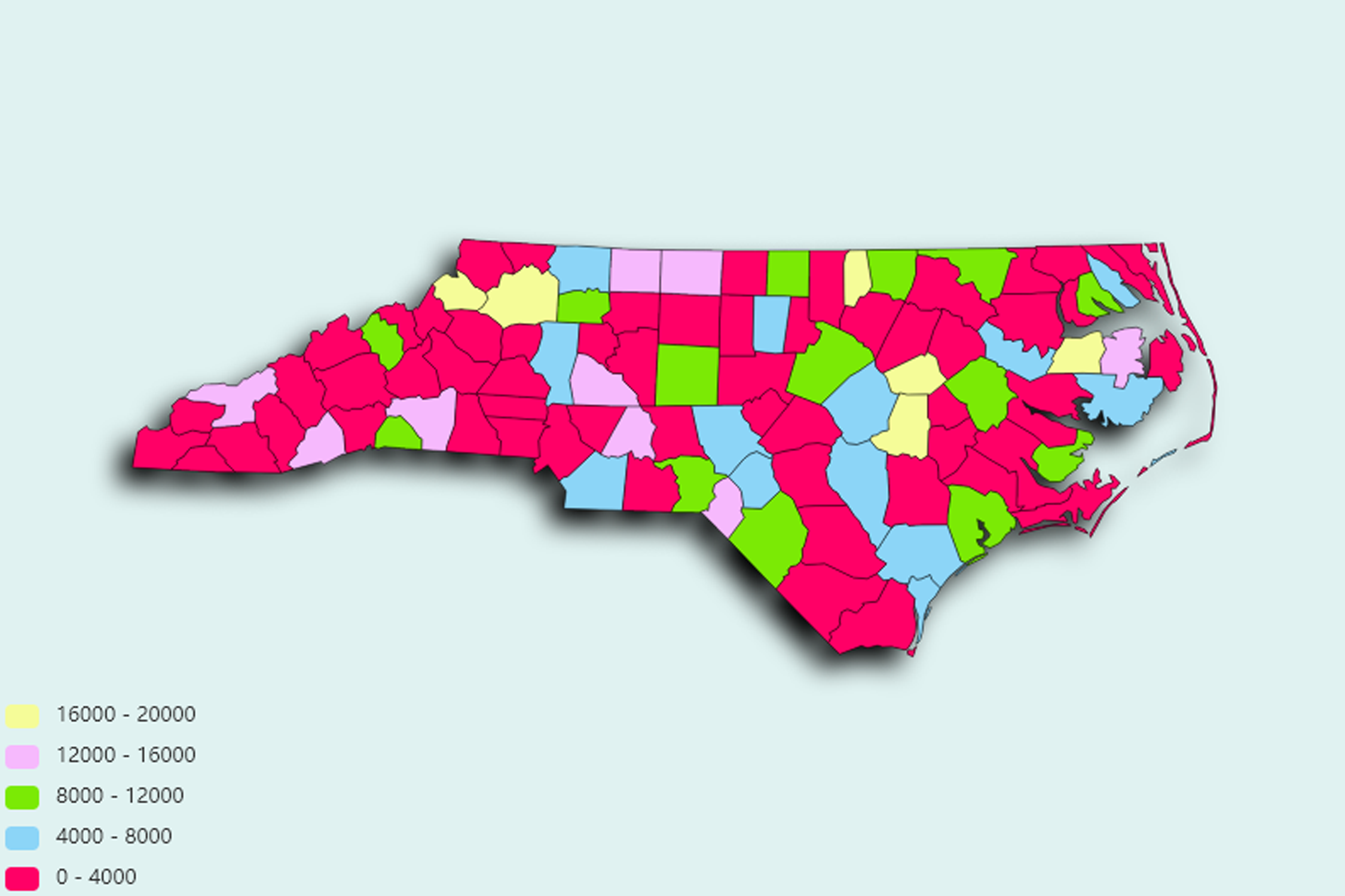
North Carolina State Statistics
About: Virginia Dare, the first English child born in America, on Roanoake Island in 1587
![]() Population: 809958
Population: 809958
![]() Population: 439896
Population: 439896
![]() Population: 282586
Population: 282586
![]() Population: 251893
Population: 251893
![]() Population: 239269
Population: 239269
![]() Population: 203948
Population: 203948
![]() Population: 155227
Population: 155227
![]() Population: 113657
Population: 113657
![]() Population: 108629
Population: 108629
![]() Population: 89852
Population: 89852
![]() Population: 87882
Population: 87882
![]() Population: 85560
Population: 85560
![]() Population: 73698
Population: 73698
![]() Population: 69047
Population: 69047
![]() Population: 59376
Population: 59376
![]() Population: 56325
Population: 56325
![]() Population: 51812
Population: 51812
![]() Population: 51567
Population: 51567
![]() Population: 49395
Population: 49395
![]() Population: 45245
Population: 45245
![]() Population: 43907
Population: 43907
![]() Population: 40143
Population: 40143
![]() Population: 36693
Population: 36693
![]() Population: 36360
Population: 36360
![]() Population: 35947
Population: 35947
![]() Population: 35300
Population: 35300
![]() Population: 34331
Population: 34331
![]() Population: 33710
Population: 33710
![]() Population: 30291
Population: 30291
![]() Population: 30157
Population: 30157
![]() Population: 30008
Population: 30008
![]() Population: 29731
Population: 29731
![]() Population: 29116
Population: 29116
![]() Population: 27814
Population: 27814
![]() Population: 27481
Population: 27481
![]() Population: 27002
Population: 27002
![]() Population: 25886
Population: 25886
![]() Population: 25722
Population: 25722
![]() Population: 25076
Population: 25076
![]() Population: 23739
Population: 23739
![]() Population: 22772
Population: 22772
![]() Population: 22644
Population: 22644
![]() Population: 21716
Population: 21716
![]() Population: 21392
Population: 21392
![]() Population: 20984
Population: 20984
![]() Population: 20706
Population: 20706
![]() Population: 20276
Population: 20276
![]() Population: 19522
Population: 19522
![]() Population: 19257
Population: 19257
![]() Population: 18445
Population: 18445
![]() Population: 18130
Population: 18130
![]() Population: 18047
Population: 18047
![]() Population: 17920
Population: 17920
![]() Population: 17015
Population: 17015
![]() Population: 16690
Population: 16690
![]() Population: 16301
Population: 16301
![]() Population: 15976
Population: 15976
![]() Population: 15593
Population: 15593
![]() Population: 15495
Population: 15495
![]() Population: 15434
Population: 15434
![]() Population: 15407
Population: 15407
![]() Population: 15265
Population: 15265
![]() Population: 14968
Population: 14968
![]() Population: 14479
Population: 14479
![]() Population: 14215
Population: 14215
![]() Population: 14132
Population: 14132
![]() Population: 14073
Population: 14073
![]() Population: 14016
Population: 14016
![]() Population: 13958
Population: 13958
![]() Population: 13871
Population: 13871
![]() Population: 13650
Population: 13650
![]() Population: 13370
Population: 13370
![]() Population: 13342
Population: 13342
![]() Population: 13293
Population: 13293
![]() Population: 13277
Population: 13277
![]() Population: 13235
Population: 13235
![]() Population: 13005
Population: 13005
![]() Population: 12750
Population: 12750
![]() Population: 11981
Population: 11981
![]() Population: 11735
Population: 11735
![]() Population: 11539
Population: 11539
![]() Population: 11310
Population: 11310
![]() Population: 10753
Population: 10753
![]() Population: 10732
Population: 10732
![]() Population: 10644
Population: 10644
![]() Population: 10456
Population: 10456
![]() Population: 10383
Population: 10383
![]() Population: 10322
Population: 10322
![]() Population: 9789
Population: 9789
![]() Population: 9761
Population: 9761
![]() Population: 9710
Population: 9710
![]() Population: 9630
Population: 9630
![]() Population: 9511
Population: 9511
![]() Population: 9276
Population: 9276
![]() Population: 9258
Population: 9258
![]() Population: 8875
Population: 8875
![]() Population: 8787
Population: 8787
![]() Population: 8759
Population: 8759
![]() Population: 8713
Population: 8713
![]() Population: 8352
Population: 8352
![]() Population: 8304
Population: 8304
![]() Population: 8273
Population: 8273
![]() Population: 8236
Population: 8236
![]() Population: 8215
Population: 8215
![]() Population: 8192
Population: 8192
![]() Population: 8145
Population: 8145
![]() Population: 8113
Population: 8113
![]() Population: 7885
Population: 7885
![]() Population: 7718
Population: 7718
![]() Population: 7692
Population: 7692
![]() Population: 7487
Population: 7487
![]() Population: 7419
Population: 7419
![]() Population: 7411
Population: 7411
![]() Population: 7345
Population: 7345
![]() Population: 7324
Population: 7324
![]() Population: 7131
Population: 7131
![]() Population: 7085
Population: 7085
![]() Population: 6944
Population: 6944
![]() Population: 6931
Population: 6931
![]() Population: 6887
Population: 6887
![]() Population: 6766
Population: 6766
![]() Population: 6697
Population: 6697
![]() Population: 6662
Population: 6662
![]() Population: 6604
Population: 6604
![]() Population: 6513
Population: 6513
![]() Population: 6442
Population: 6442
![]() Population: 6388
Population: 6388
![]() Population: 6283
Population: 6283
![]() Population: 6257
Population: 6257
![]() Population: 6228
Population: 6228
![]() Population: 6204
Population: 6204
![]() Population: 6182
Population: 6182
![]() Population: 6060
Population: 6060
![]() Population: 6042
Population: 6042
![]() Population: 5906
Population: 5906
![]() Population: 5899
Population: 5899
![]() Population: 5785
Population: 5785
![]() Population: 5762
Population: 5762
![]() Population: 5689
Population: 5689
![]() Population: 5620
Population: 5620
![]() Population: 5601
Population: 5601
![]() Population: 5598
Population: 5598
![]() Population: 5484
Population: 5484
![]() Population: 5464
Population: 5464
![]() Population: 5424
Population: 5424
![]() Population: 5322
Population: 5322
![]() Population: 5289
Population: 5289
![]() Population: 5122
Population: 5122
![]() Population: 5104
Population: 5104
![]() Population: 5059
Population: 5059
North Carolina State, constituent state of the United States of America. One of the 13 original states, it lies on the Atlantic coast midway between New York and Florida and is bounded to the north by Virginia, to the east by the Atlantic Ocean, to the south by South Carolina and Georgia, and to the west by Tennessee. The terrain of North Carolina is among the wettest in the country, with vast marshlands in the coastal tidewater area and numerous lakes in the Piedmont and Appalachian regions.

About: Virginia Dare, the first English child born in America, on Roanoake Island in 1587