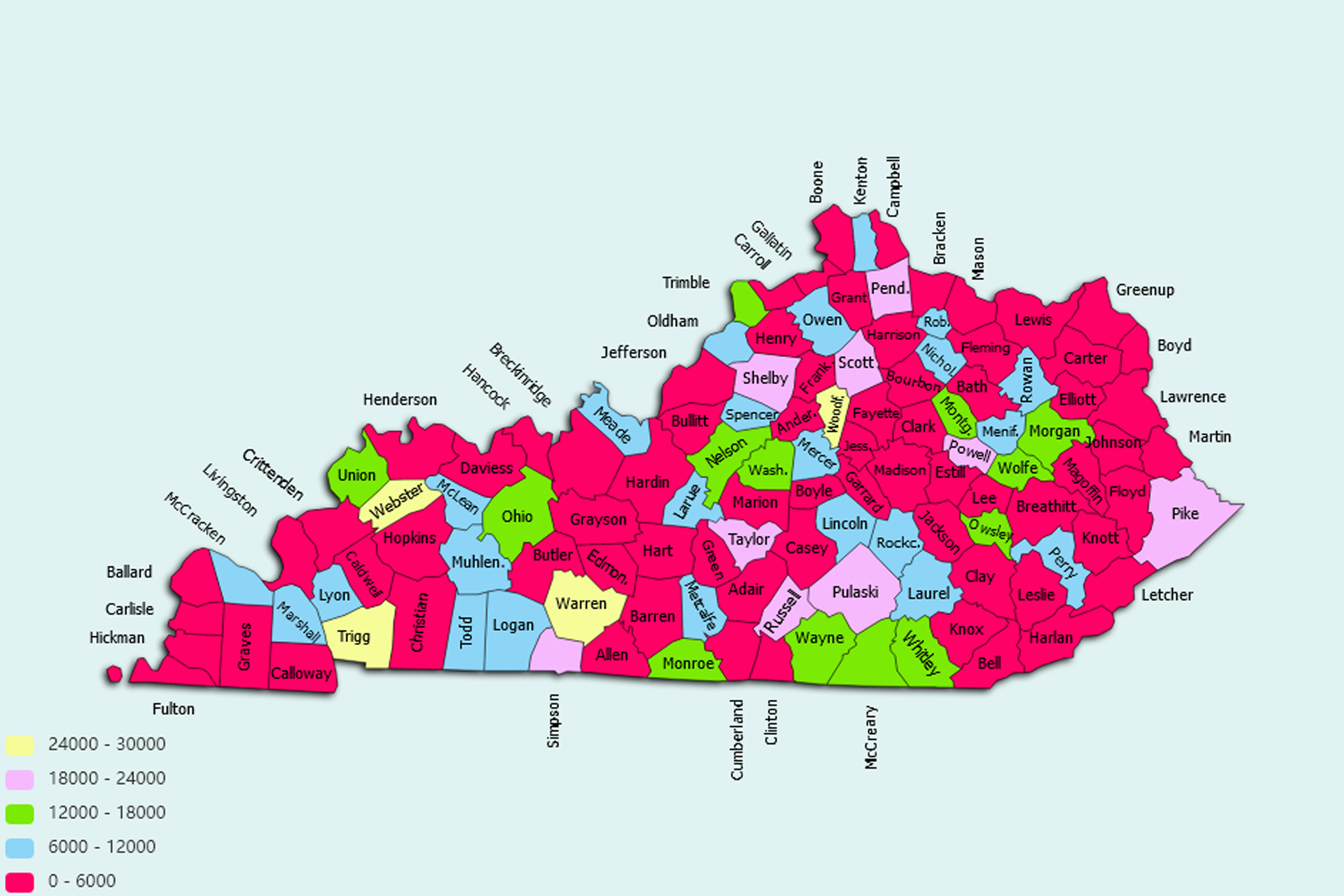
Kentucky State Statistics
About: Find out about your mental health and make a difference to everyday in your life.
![]() Population: 310797
Population: 310797
![]() Population: 286518
Population: 286518
![]() Population: 262764
Population: 262764
![]() Population: 62479
Population: 62479
![]() Population: 58374
Population: 58374
![]() Population: 40944
Population: 40944
![]() Population: 33556
Population: 33556
![]() Population: 32634
Population: 32634
![]() Population: 31888
Population: 31888
![]() Population: 31653
Population: 31653
![]() Population: 29974
Population: 29974
![]() Population: 29097
Population: 29097
![]() Population: 28900
Population: 28900
![]() Population: 27557
Population: 27557
![]() Population: 26949
Population: 26949
![]() Population: 26433
Population: 26433
![]() Population: 26378
Population: 26378
![]() Population: 24978
Population: 24978
![]() Population: 23531
Population: 23531
![]() Population: 22952
Population: 22952
![]() Population: 21335
Population: 21335
![]() Population: 21162
Population: 21162
![]() Population: 19622
Population: 19622
![]() Population: 18647
Population: 18647
![]() Population: 18630
Population: 18630
![]() Population: 18443
Population: 18443
![]() Population: 18325
Population: 18325
![]() Population: 18261
Population: 18261
![]() Population: 17911
Population: 17911
![]() Population: 17198
Population: 17198
![]() Population: 16620
Population: 16620
![]() Population: 16329
Population: 16329
![]() Population: 15926
Population: 15926
![]() Population: 15643
Population: 15643
![]() Population: 15547
Population: 15547
![]() Population: 15426
Population: 15426
![]() Population: 14985
Population: 14985
![]() Population: 14658
Population: 14658
![]() Population: 14339
Population: 14339
![]() Population: 13685
Population: 13685
![]() Population: 13050
Population: 13050
![]() Population: 12998
Population: 12998
![]() Population: 12246
Population: 12246
![]() Population: 12202
Population: 12202
![]() Population: 11944
Population: 11944
![]() Population: 11856
Population: 11856
![]() Population: 11422
Population: 11422
![]() Population: 11311
Population: 11311
![]() Population: 11282
Population: 11282
![]() Population: 11093
Population: 11093
![]() Population: 10124
Population: 10124
![]() Population: 10122
Population: 10122
![]() Population: 9872
Population: 9872
![]() Population: 9747
Population: 9747
![]() Population: 9411
Population: 9411
![]() Population: 9054
Population: 9054
![]() Population: 9036
Population: 9036
![]() Population: 8991
Population: 8991
![]() Population: 8851
Population: 8851
![]() Population: 8790
Population: 8790
![]() Population: 8741
Population: 8741
![]() Population: 8695
Population: 8695
![]() Population: 8516
Population: 8516
![]() Population: 8507
Population: 8507
![]() Population: 8361
Population: 8361
![]() Population: 8266
Population: 8266
![]() Population: 8126
Population: 8126
![]() Population: 8002
Population: 8002
![]() Population: 7944
Population: 7944
![]() Population: 7942
Population: 7942
![]() Population: 7853
Population: 7853
![]() Population: 7592
Population: 7592
![]() Population: 7525
Population: 7525
![]() Population: 7515
Population: 7515
![]() Population: 7457
Population: 7457
![]() Population: 7429
Population: 7429
![]() Population: 7426
Population: 7426
![]() Population: 7422
Population: 7422
![]() Population: 7405
Population: 7405
![]() Population: 7327
Population: 7327
![]() Population: 7308
Population: 7308
![]() Population: 7194
Population: 7194
![]() Population: 7178
Population: 7178
![]() Population: 7067
Population: 7067
![]() Population: 7050
Population: 7050
![]() Population: 7038
Population: 7038
![]() Population: 6978
Population: 6978
![]() Population: 6872
Population: 6872
![]() Population: 6728
Population: 6728
![]() Population: 6365
Population: 6365
![]() Population: 6279
Population: 6279
![]() Population: 6249
Population: 6249
![]() Population: 6199
Population: 6199
![]() Population: 6161
Population: 6161
![]() Population: 6123
Population: 6123
![]() Population: 6095
Population: 6095
![]() Population: 5961
Population: 5961
![]() Population: 5919
Population: 5919
![]() Population: 5899
Population: 5899
![]() Population: 5861
Population: 5861
![]() Population: 5837
Population: 5837
![]() Population: 5760
Population: 5760
![]() Population: 5738
Population: 5738
![]() Population: 5733
Population: 5733
![]() Population: 5640
Population: 5640
![]() Population: 5621
Population: 5621
![]() Population: 5617
Population: 5617
![]() Population: 5427
Population: 5427
![]() Population: 5387
Population: 5387
![]() Population: 5376
Population: 5376
![]() Population: 5346
Population: 5346
![]() Population: 5274
Population: 5274
![]() Population: 5220
Population: 5220
![]() Population: 5183
Population: 5183
![]() Population: 5157
Population: 5157
![]() Population: 5117
Population: 5117
![]() Population: 5029
Population: 5029
![]() Population: 5017
Population: 5017
Kentucky State, constituent state of the United States of America. Rivers define Kentucky’s boundaries except on the south, where it shares a border with Tennessee along a nearly straight line of about 425 miles (685 km), and on the southeast, where it shares an irregular, mountainous border with Virginia. Flowing generally northwestward, the Tug and Big Sandy rivers separate Kentucky from West Virginia on the east and northeast.

About: Find out about your mental health and make a difference to everyday in your life.