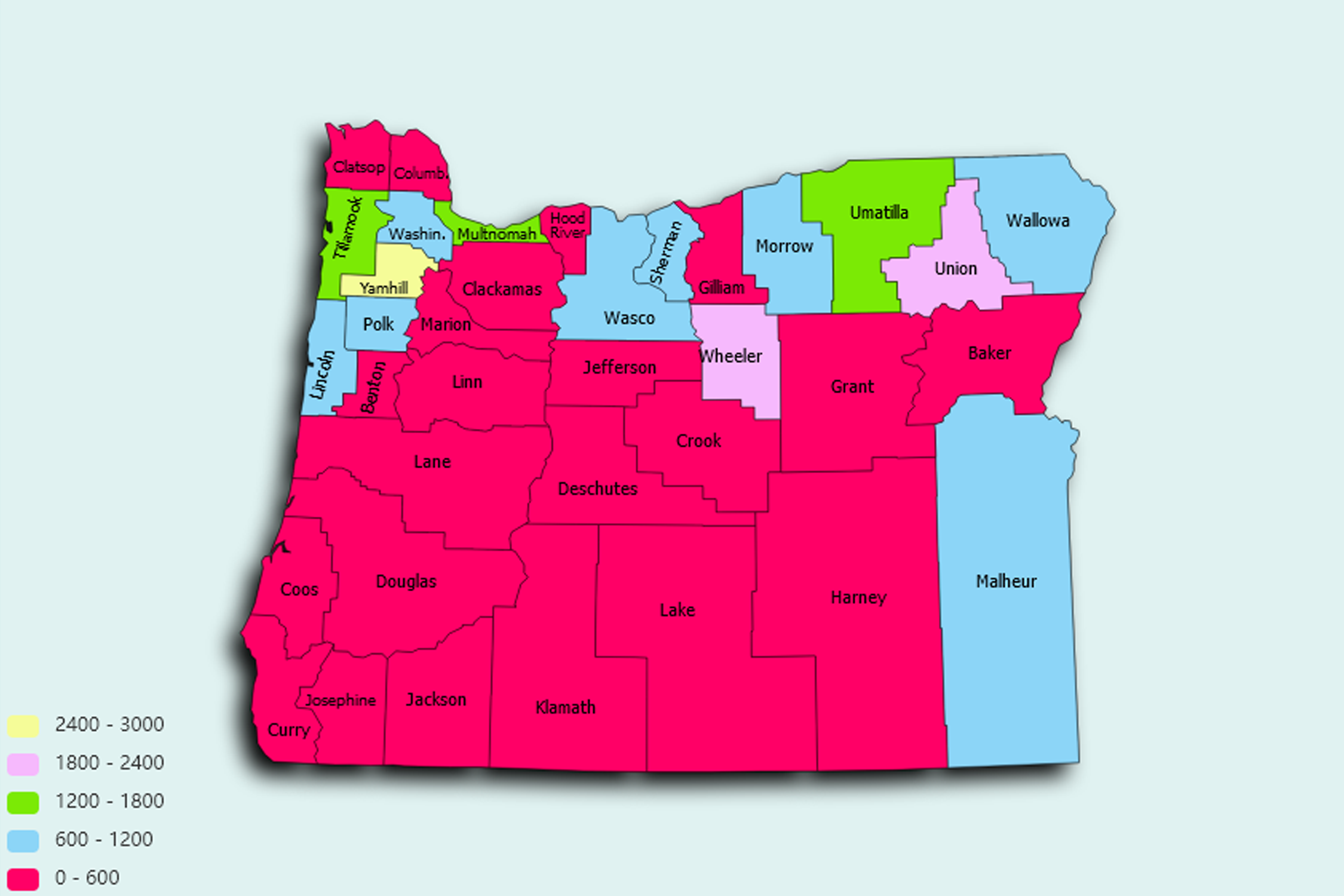
Oregon State Statistics
About: The world's smallest park, totaling 452 inches, created in Portland on St. Patrick's Day for leprechauns and snail races
![]() Population: 619360
Population: 619360
![]() Population: 248034
Population: 248034
![]() Population: 161637
Population: 161637
![]() Population: 160561
Population: 160561
![]() Population: 109892
Population: 109892
![]() Population: 99393
Population: 99393
![]() Population: 95109
Population: 95109
![]() Population: 84080
Population: 84080
![]() Population: 78557
Population: 78557
![]() Population: 62062
Population: 62062
![]() Population: 60263
Population: 60263
![]() Population: 54953
Population: 54953
![]() Population: 51980
Population: 51980
![]() Population: 50787
Population: 50787
![]() Population: 49425
Population: 49425
![]() Population: 37999
Population: 37999
![]() Population: 37303
Population: 37303
![]() Population: 35272
Population: 35272
![]() Population: 35266
Population: 35266
![]() Population: 33393
Population: 33393
![]() Population: 31857
Population: 31857
![]() Population: 30810
Population: 30810
![]() Population: 27941
Population: 27941
![]() Population: 26907
Population: 26907
![]() Population: 26289
Population: 26289
![]() Population: 24734
Population: 24734
![]() Population: 23096
Population: 23096
![]() Population: 22692
Population: 22692
![]() Population: 22026
Population: 22026
![]() Population: 21903
Population: 21903
![]() Population: 21119
Population: 21119
![]() Population: 20684
Population: 20684
![]() Population: 20646
Population: 20646
![]() Population: 20640
Population: 20640
![]() Population: 19936
Population: 19936
![]() Population: 19517
Population: 19517
![]() Population: 19257
Population: 19257
![]() Population: 18978
Population: 18978
![]() Population: 17724
Population: 17724
![]() Population: 17319
Population: 17319
![]() Population: 17137
Population: 17137
![]() Population: 17010
Population: 17010
![]() Population: 16904
Population: 16904
![]() Population: 16629
Population: 16629
![]() Population: 16552
Population: 16552
![]() Population: 16508
Population: 16508
![]() Population: 16039
Population: 16039
![]() Population: 15982
Population: 15982
![]() Population: 15947
Population: 15947
![]() Population: 15102
Population: 15102
![]() Population: 14947
Population: 14947
![]() Population: 14546
Population: 14546
![]() Population: 13415
Population: 13415
![]() Population: 13061
Population: 13061
![]() Population: 13026
Population: 13026
![]() Population: 12365
Population: 12365
![]() Population: 12351
Population: 12351
![]() Population: 12185
Population: 12185
![]() Population: 12113
Population: 12113
![]() Population: 12054
Population: 12054
![]() Population: 11888
Population: 11888
![]() Population: 11715
Population: 11715
![]() Population: 11623
Population: 11623
![]() Population: 11559
Population: 11559
![]() Population: 11333
Population: 11333
![]() Population: 10982
Population: 10982
![]() Population: 10893
Population: 10893
![]() Population: 10786
Population: 10786
![]() Population: 10309
Population: 10309
![]() Population: 10116
Population: 10116
![]() Population: 9950
Population: 9950
![]() Population: 9845
Population: 9845
![]() Population: 9801
Population: 9801
![]() Population: 9543
Population: 9543
![]() Population: 9521
Population: 9521
![]() Population: 9493
Population: 9493
![]() Population: 9469
Population: 9469
![]() Population: 9316
Population: 9316
![]() Population: 9258
Population: 9258
![]() Population: 9218
Population: 9218
![]() Population: 9133
Population: 9133
![]() Population: 9074
Population: 9074
![]() Population: 9013
Population: 9013
![]() Population: 8768
Population: 8768
![]() Population: 8753
Population: 8753
![]() Population: 8506
Population: 8506
![]() Population: 8422
Population: 8422
![]() Population: 8300
Population: 8300
![]() Population: 8036
Population: 8036
![]() Population: 8001
Population: 8001
![]() Population: 7975
Population: 7975
![]() Population: 7848
Population: 7848
![]() Population: 7846
Population: 7846
![]() Population: 7762
Population: 7762
![]() Population: 7722
Population: 7722
![]() Population: 7515
Population: 7515
![]() Population: 7512
Population: 7512
![]() Population: 7476
Population: 7476
![]() Population: 7350
Population: 7350
![]() Population: 7315
Population: 7315
![]() Population: 7286
Population: 7286
![]() Population: 7088
Population: 7088
![]() Population: 7005
Population: 7005
![]() Population: 6978
Population: 6978
![]() Population: 6856
Population: 6856
![]() Population: 6674
Population: 6674
![]() Population: 6605
Population: 6605
![]() Population: 6564
Population: 6564
![]() Population: 6554
Population: 6554
![]() Population: 6533
Population: 6533
![]() Population: 6492
Population: 6492
![]() Population: 6472
Population: 6472
![]() Population: 6407
Population: 6407
![]() Population: 6346
Population: 6346
![]() Population: 6323
Population: 6323
![]() Population: 6065
Population: 6065
![]() Population: 5912
Population: 5912
![]() Population: 5896
Population: 5896
![]() Population: 5726
Population: 5726
![]() Population: 5718
Population: 5718
![]() Population: 5708
Population: 5708
![]() Population: 5694
Population: 5694
![]() Population: 5665
Population: 5665
![]() Population: 5557
Population: 5557
![]() Population: 5530
Population: 5530
![]() Population: 5462
Population: 5462
![]() Population: 5381
Population: 5381
![]() Population: 5342
Population: 5342
![]() Population: 5173
Population: 5173
![]() Population: 5102
Population: 5102
![]() Population: 5077
Population: 5077
![]() Population: 5024
Population: 5024
![]() Population: 5011
Population: 5011
![]() Population: 5001
Population: 5001
Oregon State, constituent state of the United States of America. Oregon is bounded to the north by Washington state, from which it receives the waters of the Columbia River; to the east by Idaho, more than half the border with which is formed by the winding Snake River and Hells Canyon; to the south by Nevada and California, with which Oregon shares its mountain and desert systems; and to the west by the Pacific Ocean, which produces the moderate climate of Oregon’s western lands.

About: The world's smallest park, totaling 452 inches, created in Portland on St. Patrick's Day for leprechauns and snail races