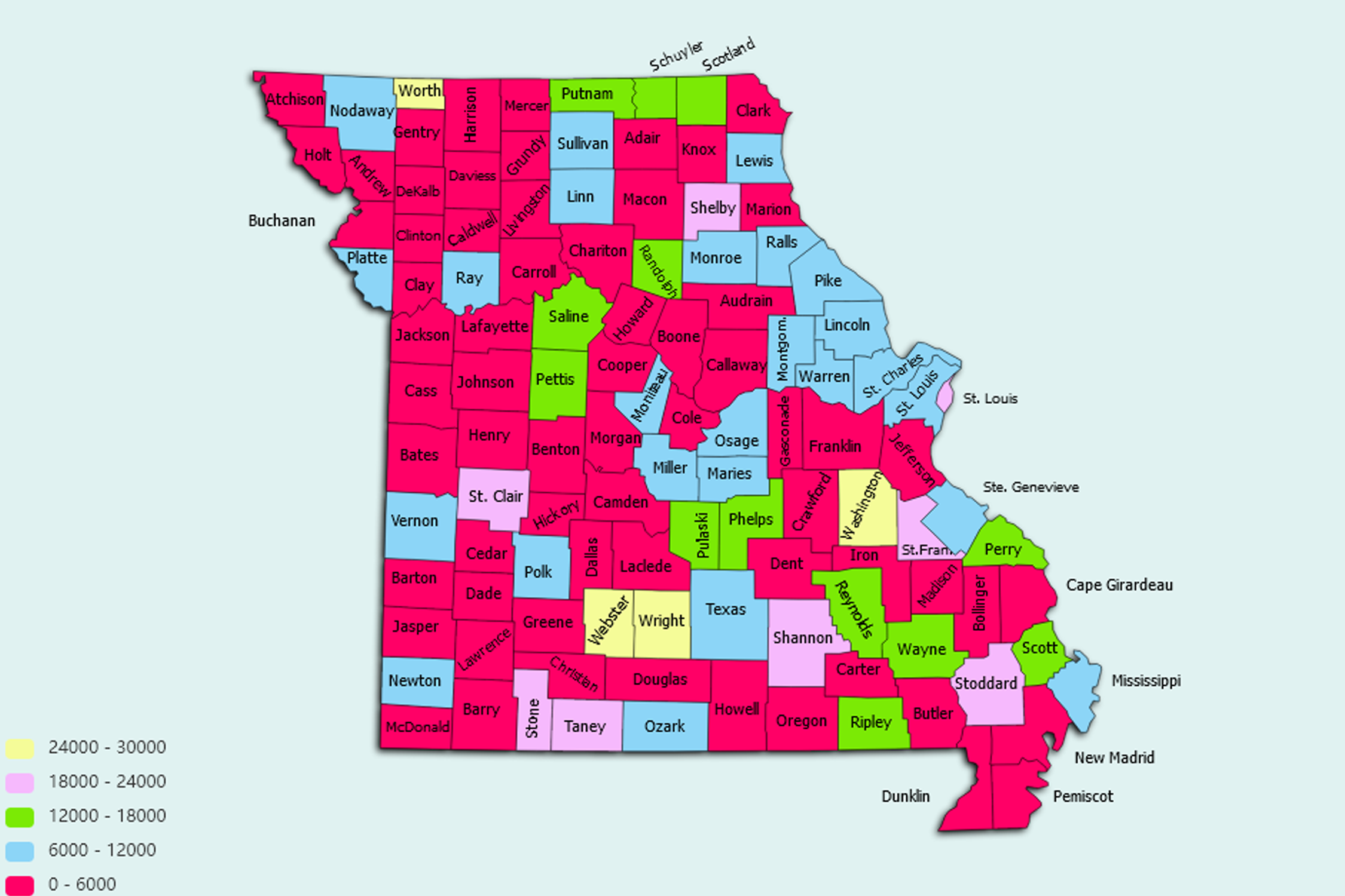
Missouri State Statistics
About: Find out about your mental health and make a difference to everyday in your life.
![]() Population: 470800
Population: 470800
![]() Population: 317419
Population: 317419
![]() Population: 165378
Population: 165378
![]() Population: 117494
Population: 117494
![]() Population: 116906
Population: 116906
![]() Population: 93864
Population: 93864
![]() Population: 84009
Population: 84009
![]() Population: 76967
Population: 76967
![]() Population: 68090
Population: 68090
![]() Population: 56076
Population: 56076
![]() Population: 53573
Population: 53573
![]() Population: 52303
Population: 52303
![]() Population: 51316
Population: 51316
![]() Population: 47777
Population: 47777
![]() Population: 43132
Population: 43132
![]() Population: 39167
Population: 39167
![]() Population: 36143
Population: 36143
![]() Population: 35820
Population: 35820
![]() Population: 35115
Population: 35115
![]() Population: 33912
Population: 33912
![]() Population: 30505
Population: 30505
![]() Population: 30376
Population: 30376
![]() Population: 29481
Population: 29481
![]() Population: 28380
Population: 28380
![]() Population: 27660
Population: 27660
![]() Population: 27405
Population: 27405
![]() Population: 26800
Population: 26800
![]() Population: 25666
Population: 25666
![]() Population: 25290
Population: 25290
![]() Population: 23186
Population: 23186
![]() Population: 23165
Population: 23165
![]() Population: 21492
Population: 21492
![]() Population: 21243
Population: 21243
![]() Population: 21086
Population: 21086
![]() Population: 20570
Population: 20570
![]() Population: 20307
Population: 20307
![]() Population: 19963
Population: 19963
![]() Population: 19963
Population: 19963
![]() Population: 19926
Population: 19926
![]() Population: 19650
Population: 19650
![]() Population: 19184
Population: 19184
![]() Population: 18871
Population: 18871
![]() Population: 18197
Population: 18197
![]() Population: 17915
Population: 17915
![]() Population: 17893
Population: 17893
![]() Population: 17868
Population: 17868
![]() Population: 17633
Population: 17633
![]() Population: 17242
Population: 17242
![]() Population: 16645
Population: 16645
![]() Population: 16421
Population: 16421
![]() Population: 16370
Population: 16370
![]() Population: 15985
Population: 15985
![]() Population: 15882
Population: 15882
![]() Population: 15680
Population: 15680
![]() Population: 15061
Population: 15061
![]() Population: 15014
Population: 15014
![]() Population: 14737
Population: 14737
![]() Population: 14677
Population: 14677
![]() Population: 14650
Population: 14650
![]() Population: 14271
Population: 14271
![]() Population: 14020
Population: 14020
![]() Population: 13890
Population: 13890
![]() Population: 13236
Population: 13236
![]() Population: 13042
Population: 13042
![]() Population: 12955
Population: 12955
![]() Population: 12864
Population: 12864
![]() Population: 12783
Population: 12783
![]() Population: 12275
Population: 12275
![]() Population: 12134
Population: 12134
![]() Population: 12007
Population: 12007
![]() Population: 11951
Population: 11951
![]() Population: 11885
Population: 11885
![]() Population: 11782
Population: 11782
![]() Population: 11664
Population: 11664
![]() Population: 11488
Population: 11488
![]() Population: 11355
Population: 11355
![]() Population: 11340
Population: 11340
![]() Population: 11075
Population: 11075
![]() Population: 10975
Population: 10975
![]() Population: 10859
Population: 10859
![]() Population: 10807
Population: 10807
![]() Population: 10796
Population: 10796
![]() Population: 10572
Population: 10572
![]() Population: 10543
Population: 10543
![]() Population: 9983
Population: 9983
![]() Population: 9762
Population: 9762
![]() Population: 9504
Population: 9504
![]() Population: 9261
Population: 9261
![]() Population: 9253
Population: 9253
![]() Population: 9107
Population: 9107
![]() Population: 9084
Population: 9084
![]() Population: 9015
Population: 9015
![]() Population: 8934
Population: 8934
![]() Population: 8690
Population: 8690
![]() Population: 8618
Population: 8618
![]() Population: 8576
Population: 8576
![]() Population: 8534
Population: 8534
![]() Population: 8527
Population: 8527
![]() Population: 8495
Population: 8495
![]() Population: 8394
Population: 8394
![]() Population: 8374
Population: 8374
![]() Population: 8295
Population: 8295
![]() Population: 8250
Population: 8250
![]() Population: 8068
Population: 8068
![]() Population: 8043
Population: 8043
![]() Population: 7969
Population: 7969
![]() Population: 7959
Population: 7959
![]() Population: 7873
Population: 7873
![]() Population: 7845
Population: 7845
![]() Population: 7660
Population: 7660
![]() Population: 7580
Population: 7580
![]() Population: 7450
Population: 7450
![]() Population: 7113
Population: 7113
![]() Population: 7054
Population: 7054
![]() Population: 7031
Population: 7031
![]() Population: 6977
Population: 6977
![]() Population: 6976
Population: 6976
![]() Population: 6935
Population: 6935
![]() Population: 6475
Population: 6475
![]() Population: 6471
Population: 6471
![]() Population: 6205
Population: 6205
![]() Population: 6098
Population: 6098
![]() Population: 5975
Population: 5975
![]() Population: 5955
Population: 5955
![]() Population: 5925
Population: 5925
![]() Population: 5925
Population: 5925
![]() Population: 5907
Population: 5907
![]() Population: 5747
Population: 5747
![]() Population: 5682
Population: 5682
![]() Population: 5638
Population: 5638
![]() Population: 5617
Population: 5617
![]() Population: 5553
Population: 5553
![]() Population: 5505
Population: 5505
![]() Population: 5482
Population: 5482
![]() Population: 5476
Population: 5476
![]() Population: 5454
Population: 5454
![]() Population: 5429
Population: 5429
![]() Population: 5365
Population: 5365
![]() Population: 5173
Population: 5173
![]() Population: 5129
Population: 5129
![]() Population: 5005
Population: 5005
![]() Population: 5005
Population: 5005
Missouri State, constituent state of the United States of America. To the north lies Iowa; across the Mississippi River to the east, Illinois, Kentucky, and Tennessee; to the south, Arkansas; and to the west, Oklahoma, Kansas, and Nebraska. With the exception of Tennessee, Missouri has more neighbouring states than any other U.S. state. Bisecting the state is the Missouri River, flowing from Kansas City in the west, through the state’s capital, Jefferson City, in the centre, to just above St. Louis in the east, where it joins the Mississippi.

About: Find out about your mental health and make a difference to everyday in your life.